
File size: 2,873 Bytes
eb651d9 b671ddb eb651d9 b671ddb |
1 2 3 4 5 6 7 8 9 10 11 12 13 14 15 16 17 18 19 20 21 22 23 24 25 26 27 28 29 30 31 32 33 34 35 36 37 38 39 40 41 42 43 44 45 46 47 48 49 50 51 |
---
license: cc-by-nc-nd-4.0
task_categories:
- image-classification
- image-to-image
language:
- en
tags:
- code
---
# Parking Space Detection & Classification Dataset
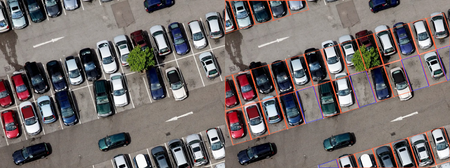
The dataset consists of images of parking spaces along with corresponding bounding box masks. In order to facilitate object detection and localization, every parking space in the images is annotated with a bounding box mask.
The bounding box mask outlines the boundary of the parking space, marking its position and shape within the image. This allows for accurate identification and extraction of individual parking spaces. Each parking spot is also labeled in accordance to its occupancy: **free, not free or partially free**.
This dataset can be leveraged for a range of applications such as *parking lot management, autonomous vehicle navigation, smart city implementations, and traffic analysis*.
# Get the Dataset
### This is just an example of the data
Contact us via **[[email protected]](mailto:[email protected])** or leave a request on **[https://trainingdata.pro/data-market](https://trainingdata.pro/data-market?utm_source=huggingface)** to discuss your requirements, learn about the price and buy the dataset
# Dataset structure
- **images** - contains of original images of parkings
- **boxes** - includes bounding box labeling for the original images
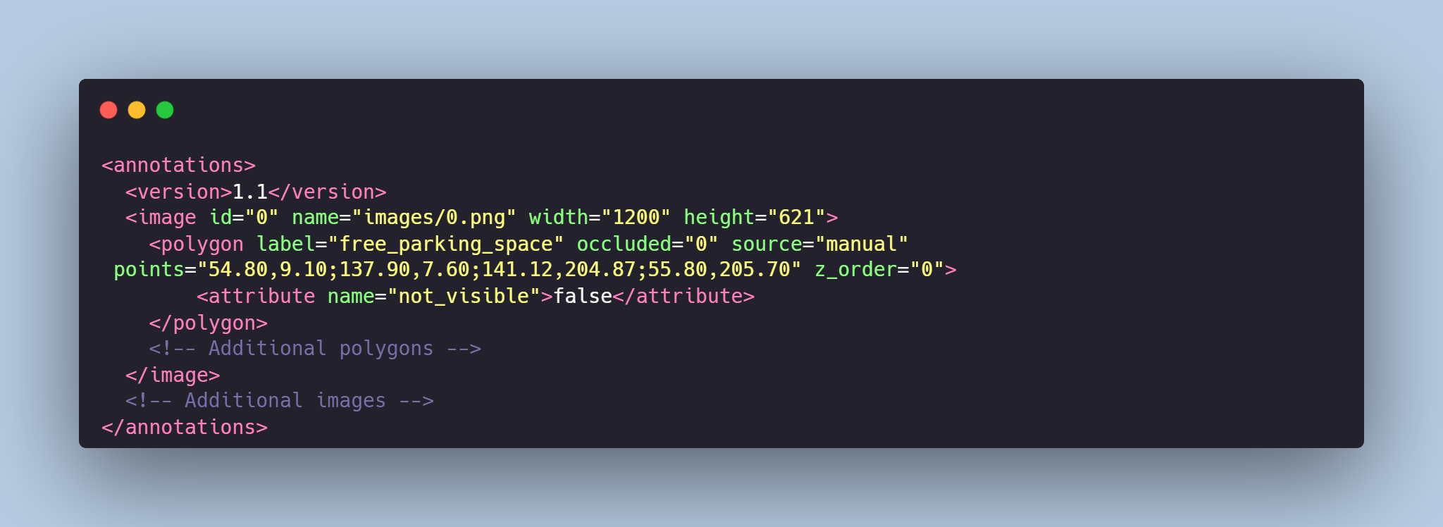
- **annotations.xml** - contains coordinates of the bounding boxes and labels, created for the original photo
# Data Format
Each image from `images` folder is accompanied by an XML-annotation in the `annotations.xml` file indicating the coordinates of the bounding boxes and labels for parking spaces. For each point, the x and y coordinates are provided.
### Labels for the parking space:
- **free_parking_space** - corresponds to free parking spaces, the box is **blue**
- **not_free_parking_space** - corresponds to occupied parking spaces, the box is **red**
- **partially_free_parking_space** - corresponds to partially free parking spaces, the box is **yellow**
# Example of XML file structure
# Parking Space Detection & Classification might be made in accordance with your requirements.
## **[TrainingData](https://trainingdata.pro/data-market?utm_source=huggingface)** provides high-quality data annotation tailored to your needs
More datasets in TrainingData's Kaggle account: **https://www.kaggle.com/trainingdatapro/datasets**
TrainingData's GitHub: **https://github.com/Trainingdata-datamarket/TrainingData_All_datasets** |